
Deep Learning-Assisted Thm-Integrated Insar Modeling for Co2 Storage Characterization and Surface Deformation Forecasting
准确刻画地质碳封存(GCS)储层的地下属性,是保障长期封存安全、降低 CO₂ 泄漏风险的关键。本文提出一套全新的 CO₂ 储层表征框架:首先运行热-流-固(THM)耦合正演,获得 CO₂ 注入引起的地表形变;随后以 InSAR 观测到的高分辨率地表形变作为输入,利用 pix2pix 深度学习模型反演储层岩相与孔隙度分布。研究通过改变 InSAR 数据的信噪比(SNR)和观测时间节点,开展敏感性分析;进一步基于训练好的模型,实现 20 年尺度的 CO₂ 羽流迁移和地表形变预测。结果表明:
- 早期观测数据蕴含丰富地下信息,但对噪声极为敏感;
- 后期观测抗噪能力增强,但信息量下降;
- 该方法可准确预测长期羽流形态和形变趋势,为储层监测与风险量化提供新工具。
研究同时给出了 InSAR 采集频率与降噪策略的优化建议,为基于时序地表形变的储层表征奠定理论与应用基础。
【CMG 软件应用情况】
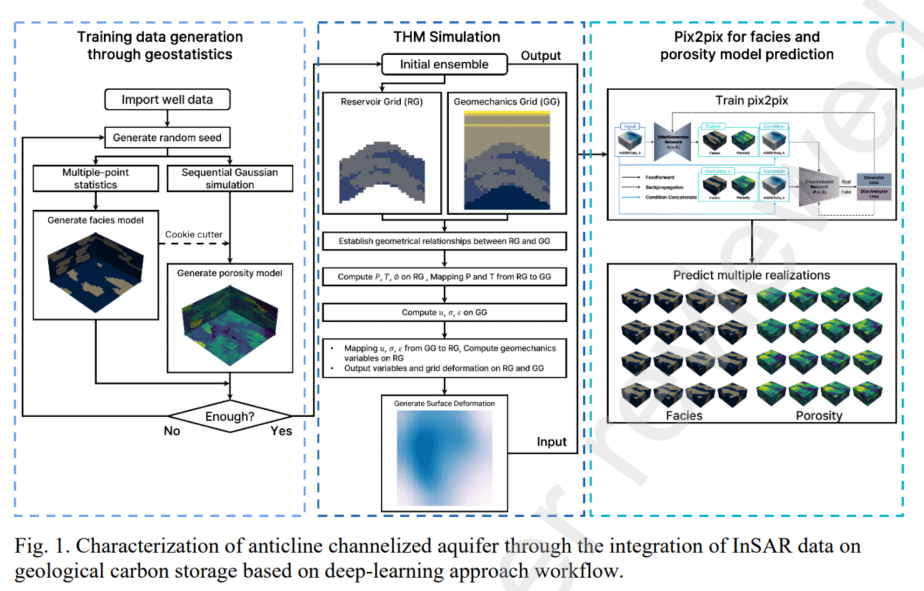
- 多相流体流动模拟:使用 CMG-GEM 进行 CO₂-卤水两相流动模拟,计算储层压力、饱和度与温度变化。
- 地质力学模拟:采用 CMG 地质力学模块,建立 32×32×37 的 Cartesian 地质力学网格,输入 GEM 所得压力场,运行 THM 耦合计算,输出地表垂向位移。
- 网格耦合:针对 GEM 角点网格(32×32×16)与地质力学 Cartesian 网格不兼容的问题,研究采用反距离加权(IDW)方法完成两套网格间的数据映射与误差控制。
- 大数据集生成:共调用 CMG 软件 4 000 次,在 4 000 个不同岩相/孔隙度实现上完成流动-地质力学正演,为 pix2pix 模型提供训练样本。
【主要结论】
- 将 CMG-GEM 与 CMG 地质力学模块联用,可真实再现 CO₂ 注入引起的储层-盖层-地表耦合响应。
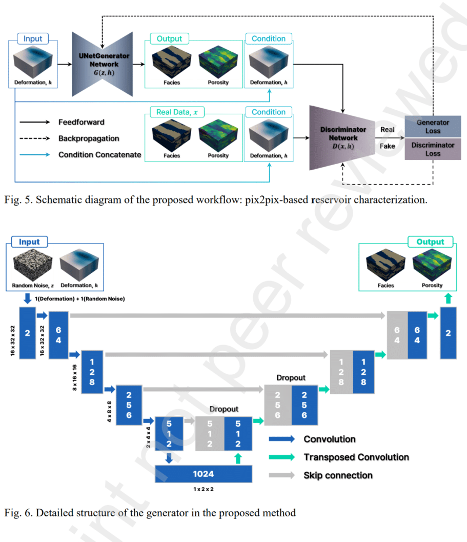
- 以地表形变驱动的 pix2pix 反演模型,能精确恢复储层岩相走向与孔隙度空间分布,显著降低先验不确定性。
- 敏感性分析指出:SNR ≥ 20 dB 是获得可靠表征的最低数据质量要求;早期(0.5–1 年)高质量 InSAR 数据价值最高;若数据噪声较大,则应延后观测以换取稳健性。
- 20 年长期预测显示,模型可稳定追踪 CO₂ 羽流扩展与地表抬升趋势,为封存稳定性评估和动态风险管理提供定量依据。
- 当前局限:尚未融合井下压力(BHP)等多源数据,也未引入连续时序 InSAR。后续工作将推进多模态数据融合与时序深度学习,以提升现场适用性。
【作者单位】
韩国仁荷大学能源资源工程系
Abstract
Accurate characterization of subsurface reservoirs in geological carbon storage (GCS) is essential for ensuring long-term storage security and mitigating leakage risks. This study proposes a novel CO2 reservoir characterization framework that integrates InSAR-based surface deformation data with a deep learning-based method (pix2pix) to predict subsurface properties, such as rock facies and porosity. To assess the surface deformation before and after CO2 injection A THM (thermal-hydrological-mechanical) simulation is employed, and their corresponding results are used as input for the suggested pix2pix-based model. To reveal the robustness of the suggested workflow, sensitivity analysis is conducted by varying signal-to-noise ratio (SNR) of InSAR data and observation time periods, assessing their impact on characterization performance. Furthermore, the model is applied for long-term CO2 plume and surface deformation predictions, enabling uncertainty quantification of future behavior.The results show that early-stage observation data provide rich subsurface information but are highly sensitive to noise, whereas later observations exhibit greater tolerance to noise but reduced information content. The suggested workflow effectively predicts long-term CO2 plume migration and surface deformation trends, demonstrating its applicability for reservoir monitoring. This study demonstrates that integrating InSAR-based surface deformation data with deep learning significantly improves CO2 reservoir characterization. The findings highlight the importance of optimizing InSAR acquisition frequency and noise-handling strategies to enhance monitoring accuracy. The proposed approach provides a foundation for developing time-series-based reservoir characterization models using surface deformation data.
Keywords: Geological Carbon Storage, Subsurface characterization, THM simulation, Surface Deformation Prediction, InSAR data, Deep learning
InSAR(Interferometric Synthetic Aperture Radar,合成孔径雷达干涉测量)是一种利用卫星或飞机搭载的 SAR 传感器,通过比对同一地区不同时间获取的两幅雷达影像的相位差异,来反演地表毫米级形变的空间遥感技术。
一句话:它让卫星雷达“两次拍照”,通过“相位差”告诉我们地面是下沉了、抬升了还是水平滑动了。
