
A phased workflow to define permit-ready locations for large volume CO2 injection and storage
迄今为止,美国环境保护局仅发放了两份UIC第六类许可证。我们展示了一个四阶段的工作流程,首先识别区域性储存资源,然后筛选出可以颁发许可证的地点,这些地点能够接受和储存大量二氧化碳(CO2)。具体的许可证要求应指导目标并定义各自工作流程阶段的交付成果。
在第一阶段,我们使用了可用的区域数据,筛选了构造和注入区域,以确定与计划捕获的CO2体积相匹配的资源。可用数据也被用来评估可用地下水的存在和深度,这是通过许可证保护的关键资源。然后,我们使用先进的封闭形式分析解决方案(EASiTool)来估算每个水文连接的注入间隔的CO2注入能力。
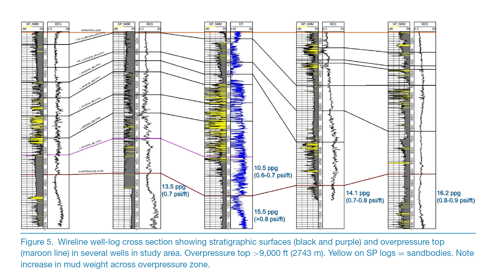
在第二阶段,我们获取并整理了额外的电缆测井记录,并租用了可用的地震数据集。我们从电缆测井记录中解释了沉积系统,并绘制了砂体几何形状,以插值注入和封闭区域的分布。利用可用数据,我们更详细地绘制了断层以及淡水和超压(或其他限制容量的地质参数)的位置。
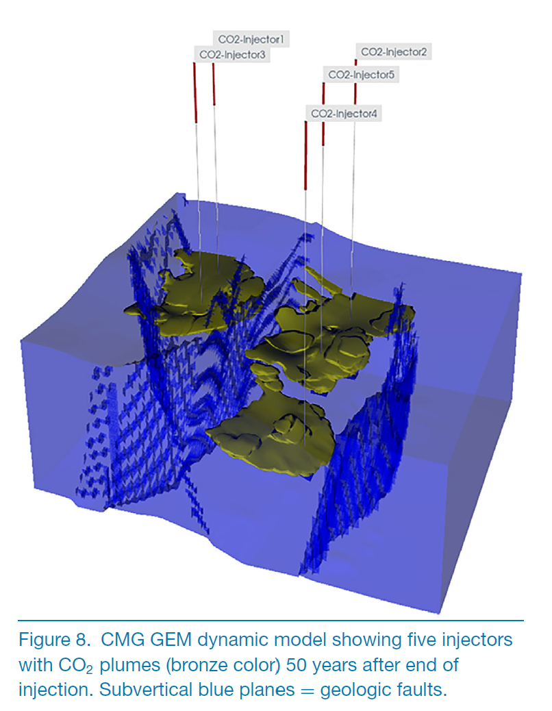
在第三阶段,我们使用增强的地质数据为选定区域开发了一个静态模型,提取了最感兴趣的区域,并生成运行了动态(流动)模型(CMG-GEM)。
在第四阶段,我们减少了早期阶段识别的主要不确定性。我们的案例研究表明,完成许可证申请的准备工作需要(1)改进的岩性特征信息(厚度以及水平和垂直连通性)和(2)对定义不清的局部断层的更好定义。
© 2023 作者。由化学工业协会和约翰·威利有限公司出版的《温室气体:科学与技术》。
Abstract
To-date, only two UIC Class VI permits have been issued by the US Environmental Protection Agency. We illustrate a four-phase workflow to first identify regional storage resources and then down-select sites to yield permit-ready locations that can accept and store large volumes of CO2. Specific permit requirements should guide objectives and define deliverables of respective workflow phases. In the first phase we used available regional data and screened structure and injection zones to locate resources that match CO2 volumes planned to be captured. Available data were also used to assess presence and depth of usable groundwater, the key resource being protected via permitting. We then used advanced, closed-form, analytical solutions (EASiTool) to estimate CO2 injectivity into each hydrologically connected injection compartment. In the second phase we acquired and conditioned additional wireline logs and leased available seismic datasets. We interpreted the depositional systems from wireline well-log character and mapped sandbody geometry to interpolate injection and confining-zone distribution. Using available data, we mapped faults and locations of freshwater and overpressure (or other capacity-limiting geologic parameters) in more detail. In the third phase, we used the augmented geologic data to develop a static model for the selected area, extracted the areas of highest interest, and generated and ran dynamic (flow) models. In a fourth phase, we reduced major uncertainties identified in earlier phases. Our case study indicates that to complete preparation of a permit application requires (1) improved lithologic characterization information (thicknesses and horizontal and vertical connectivity) and (2) better definition of poorly defined local faults.
Faults: fully transmissive
◦ Closed model boundaries
◦ Capillary pressure curve for each of the three facies (shale, silt, sandstone)
◦ Isotropic permeability kv = kh per cell (relatively thin grid cells that could capture some kv/kh effects)
◦ Reservoir pressure = 0.465 × depth (ft)
◦ Reservoir temperature = 163°F
◦ 110-ft perforation interval
