RESERVOIR ANALYSIS OF A CO2 SEQUESTRATION SITE: EXPERIMENT-GUIDED FIELD SCALE MODELING
二氧化碳(CO2)浓度是大气中存在的天然成分,从1800年开始迅速增加,标志着工业革命时期的开始。自NOAA开始测量大气CO2以来,报告显示2021年5月测得的最高CO2浓度 – 大气CO2从1958年的330ppm增至2021年的419ppm。监测CO2的重要性在于它目前占美国总温室气体排放的80%。地球辐射的热量受温室气体限制在对流层内,导致不良的全球变暖效应。
因此,气候变化政府间专门委员会(IPCC)鼓励到2050年实现“净零”人为CO2排放,并通过地质封存减少当前大气CO2含量。地质封存是指将CO2储存在地质形成中。这个过程需要引导输送和对地质形成的安全评估,以确保注入的CO2永久滞留。尽管通过4D地震数据得出的CO2饱和度图用于监测CO2注入过程中的液饱和度和压力效应,但并未提供关于CO2与先前储层流体组分相互作用的细节,这些相互作用影响田地过程。因此,基于对空间和时间液体覆盖范围的缺乏了解,来自4D地震数据的饱和度估计容易出错。
本研究提供了一个综合工作流程,用于通过由实验和测井数据引导的储层模拟来解释持续注入至枯竭油田的地震图。使用CMG-GEM®储层模拟结果,并结合流动模型,为我们提供了关于地层内发生的地球物理效应的见解。这项研究表明,油藏中的注入和生产井对CO2注入的响应不同。它还表明,油分子的运移可以更好地解释4D地震图,而不是典型的液饱和模型。仅使用储层模拟饱和度图无法解释地下过程。通过添加来自储层模拟的不同油分子的流动性变化的影响,我们能够更好地模拟4D地震响应。
ABSTRACT
The concentration of carbon dioxide (CO2), a naturally existing constituent of the atmosphere, started to rapidly increase from 1800 onwards, marking the beginning of the industrial revolution period. The highest CO2 concentration measured since NOAA started measurements of atmospheric CO2 was reported in May 2021 – atmospheric CO2 increased from 330 ppm in 1958 to 419 ppm in 2021. CO2 is important to monitor because it presently accounts for 80% of the total greenhouse gas emission by the USA. Heat radiated from the Earth is trapped within the troposphere by greenhouse gases, leading to undesirable global warming effects. The Intergovernmental Panel on Climate Change (IPCC) therefore encourages a ‘net zero’ human-caused CO2 emission by 2050 and a reduction of the present atmospheric CO2 content through geosequestration.
Geosequestration is the storage of CO2 in geologic formations. This process requires guided transport to and safety assessment of geologic formations to ensure permanent retention of the injected CO2. Although CO2 saturation maps derived from 4D seismic data have been used to monitor fluid saturation and pressure effects during CO2 injection, they provide no detail of the interactions between CO2 and the components of prior reservoir fluid which influence field processes. Thus, saturation estimates from 4D seismic data are prone to errors based on a lack of knowledge about spatial and temporal fluid coverage.
This research provides a composite workflow to interpret a seismic map from ongoing sequestration into a depleted oil field, using reservoir simulation guided by experimental and well log data. The CMG-GEM reservoir simulation results are interpreted with a flow model to provide insights on the geophysical effects occurring within the formation.
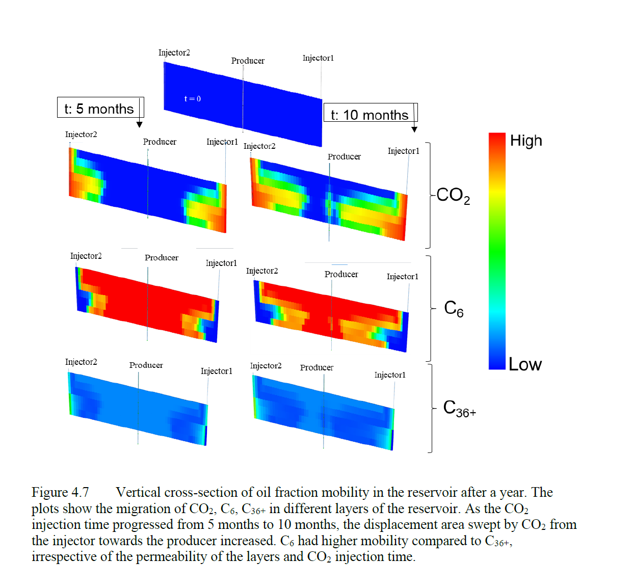
This study shows that injection and producing wells in oil reservoirs respond differently to CO2 injection. It also shows that the mobility of oil components can better explain 4D seismic maps than typical fluid saturation models. Using the reservoir simulation saturation maps alone does not explain subsurface processes. Adding effects of changing fluid mobility of the different oil components from reservoir simulations allows us to better simulate 4D seismic response.


